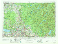
1962 Map of Utica
USGS Topo · Published 1974About this map
The Mohawk River valley serves as the primary corridor for industry and transportation in the early 1960s, linking the manufacturing hubs of Utica, Rome, and Little Falls. This region is defined by a dense network of transit including the New York State Thruway and the New York Central railroad, which parallel the historic water route. To the north, the transition into the Adirondack Mountains is marked by the sprawling Adirondack State Park, where the landscape shifts from the agricultural Tug Hill Plateau to a rugged wilderness of reservoirs and peaks. Cold War-era defense is prominent at Griffiss Air Force Base, while recreation is centered around the shores of Oneida Lake and the Stillwater Reservoir. The map illustrates the era's balance between urban expansion in Oneida and Syracuse and the preserved timberlands of the north.
Find a feature on this map
73 named features on this map. Tap any name to fly to it.
Don’t see what you’re looking for? This feature index may not catch every label — zoom into the map to look around manually.
Map Details
Editions of this 1962 Utica Map
3 editions found

Other maps of this area

1893 · Schenectady
USGS Topo · 1:62,500

1893 · Sackets Harbor
USGS Topo · 1:62,500

1895 · Chittenango
USGS Topo · 1:62,500

1895 · Sacketts Harbor
USGS Topo · 1:62,500

1895 · Oriskany
USGS Topo · 1:62,500

1895 · North Creek
USGS Topo · 1:62,500

1895 · Mt. Marcy
USGS Topo · 1:62,500

1895 · Pulaski
USGS Topo · 1:62,500

1895 · Watertown
USGS Topo · 1:62,500

1895 · Syracuse
USGS Topo · 1:62,500