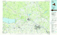
1985 Map of Utica
USGS Topo · Published 1986About this map
The Mohawk River valley serves as the central artery for this mid-1980s landscape, connecting the industrial hubs of Utica and Rome via the New York State Thruway and the Conrail lines. This era shows the region's complex infrastructure, where the historic path of the Erie Canal is mirrored by modern transit corridors. To the west, the expanse of Oneida Lake meets the shoreline at Verona Beach State Park, while the northern reaches transition into the Adirondack Park and the elevated terrain of the Tug Hill Plateau. Significant military and technological footprints are visible at Griffiss Air Force Base and several remote installations such as the Ava Test Annex. The map captures a high-water mark for these communities before the realignment of regional defense and industry, preserving the locations of smaller settlements like Taberg, Holland Patent, and Stockbridge.
Find a feature on this map
168 named features on this map. Tap any name to fly to it.
Don’t see what you’re looking for? This feature index may not catch every label — zoom into the map to look around manually.
Map Details
Editions of this 1985 Utica Map
2 editions found
Other maps of this area

1895 · Chittenango
USGS Topo · 1:62,500

1895 · Oriskany
USGS Topo · 1:62,500

1895 · Pulaski
USGS Topo · 1:62,500

1895 · Syracuse
USGS Topo · 1:62,500

1895 · Oneida
USGS Topo · 1:62,500

1897 · Cazenovia
USGS Topo · 1:62,500

1897 · Remsen
USGS Topo · 1:62,500

1898 · Oneida
USGS Topo · 1:62,500

1898 · Syracuse
USGS Topo · 1:62,500

1898 · Chittenango
USGS Topo · 1:62,500