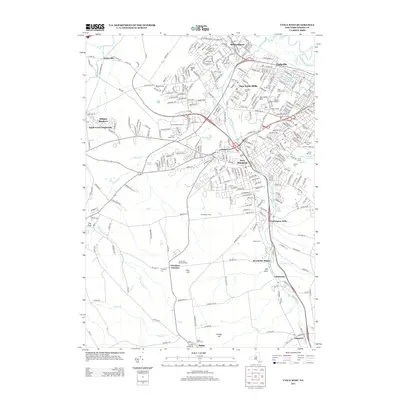
2013 Map of Utica West
USGS Topo · Published 2013About this map
Sauquoit Cr and its tributaries define the industrial and residential development of this Oneida County landscape, where the legacy of early mill towns is still visible in the dense street grids of New York Mills and Washington Mills. The map reveals a transition from the urbanized sprawl of New Hartford and Whitesboro in the north to the more open, agricultural character of the southern hills. Numerous historic burial grounds, including Crown Hill Memorial Park and Saint Joseph Cem, are interspersed among residential communities like Chuckery Corners and Brookside Manor. Academic and athletic life is anchored by the campus of Utica College and Charles A Gaetano Stadium near Burrstone Hill. From the northern reach of the Mohawk River to the high ground of Grange Hill and Crow Hill, this survey documents the complex suburban and institutional infrastructure that has replaced much of the earlier rural farmstead pattern.
Find a feature on this map
309 named features on this map. Tap any name to fly to it.
Don’t see what you’re looking for? This feature index may not catch every label — zoom into the map to look around manually.
Map Details
Editions of this 2013 Utica West Map
This is the sole edition of this map. No revisions or reprints were ever made.
Other maps of this area

1895 · Oriskany
USGS Topo · 1:62,500

1898 · Utica
USGS Topo · 1:62,500

1898 · Oriskany
USGS Topo · 1:62,500

1900 · Utica
USGS Topo · 1:62,500

1907 · Winfield
USGS Topo · 1:62,500

1907 · Sangerfield
USGS Topo · 1:62,500

1943 · Utica East
USGS Topo · 1:24,000

1943 · Cassville
USGS Topo · 1:24,000

1943 · Sangerfield
USGS Topo · 1:62,500
1943 · West Winfield
USGS Topo · 1:24,000