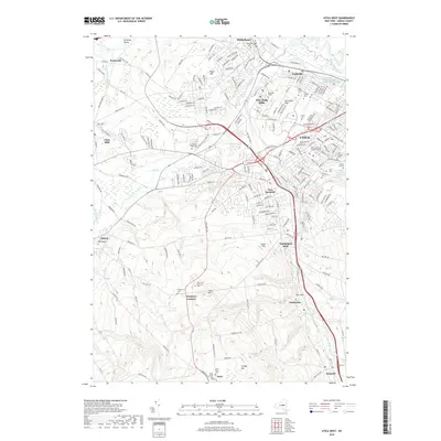
2019 Map of Utica West
USGS Topo · Published 2019About this map
Oriskany Creek and Sauquoit Creek define the industrial and residential corridors of this region south and west of the Mohawk River bend. The map illustrates a dense concentration of educational and religious institutions, including Utica Coll and the Saint Elizabeth Coll of Nursing. The area is notably dense with commemorative spaces, from the large Forest Hill Cem and Calvary Cem near the city center to the sprawling Crown Hill Memorial Park further south. High ground is marked by features like Crow Hill and Harts Hill, while the valley floors are occupied by established mill towns such as New York Mills and Washington Mills. This survey provides a precise look at the suburban expansion and modern road networks, like Clinton St, that connect the historic Mohawk Valley settlements of Yorkville and Whitesboro to the outlying agricultural areas near Walesville.
Find a feature on this map
223 named features on this map. Tap any name to fly to it.
Don’t see what you’re looking for? This feature index may not catch every label — zoom into the map to look around manually.
Map Details
Editions of this 2019 Utica West Map
This is the sole edition of this map. No revisions or reprints were ever made.
Other maps of this area

1895 · Oriskany
USGS Topo · 1:62,500

1898 · Utica
USGS Topo · 1:62,500

1898 · Oriskany
USGS Topo · 1:62,500

1900 · Utica
USGS Topo · 1:62,500

1907 · Winfield
USGS Topo · 1:62,500

1907 · Sangerfield
USGS Topo · 1:62,500

1943 · Utica East
USGS Topo · 1:24,000

1943 · Cassville
USGS Topo · 1:24,000

1943 · Sangerfield
USGS Topo · 1:62,500
1943 · West Winfield
USGS Topo · 1:24,000