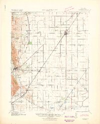
1941 Map of Vacaville
USGS Topo · Published 1941About this map
The agricultural heart of Solano County unfolds in this 1941 edition, revised from 1939 aerial photography just before the mid-century expansion of the region. The map captures the distinct grid of orchards and fields defined by the Southern Pacific and Sacramento Northern railroads, which served as the primary conduits for local commerce. Smaller railroad stops and rural junctions such as Batavia, Cannon, and Vanden appear as vital nodes in the transport network, while numerous schoolhouses like Grant School and Silveyville School illustrate the distributed nature of the rural community.
Find a feature on this map
37 named features on this map. Tap any name to fly to it.
Don’t see what you’re looking for? This feature index may not catch every label — zoom into the map to look around manually.
Map Details
Editions of this 1941 Vacaville Map
This is the sole edition of this map. No revisions or reprints were ever made.
Other maps of this area

1896 · Carquinez Strait
USGS Topo · 1:62,500

1898 · Karquines
USGS Topo · 1:62,500

1901 · Karquines
USGS Topo · 1:62,500

1902 · Napa
USGS Topo · 1:125,000

1907 · Woodland
USGS Topo · 1:62,500

1907 · Davisville
USGS Topo · 1:62,500

1907 · Antioch
USGS Topo · 1:62,500

1908 · Vacaville
USGS Topo · 1:62,500

1908 · Courtland
USGS Topo · 1:62,500

1908 · Antioch
USGS Topo · 1:62,500