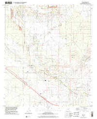
1996 Map of Vail
USGS Topo · Published 2002About this map
Vail sits at the junction of modern infrastructure and desert history, where the interstate and the southern rail corridor cross the drainage of Pantano Wash. The landscape is dominated by the Rincon Valley and the expansive Cienega Creek Natural Preserve, which protects a vital riparian corridor in this arid environment. Significant ranching history is evident through properties like Rocking K Ranch and Rancho del Lago, alongside the transition of land toward conservation in areas like Saguaro National Park. Evidence of earlier transport routes remains visible in the Old Railroad Grade and the Old Spanish Trail, while the topography rises toward Pistol Hill and the entrance to Colossal Cave Mountain Park in the east. This map documents a period of suburban expansion as the Tucson Corporate Boundary moved closer to these desert settlements and historical ranch lands.
Find a feature on this map
33 named features on this map. Tap any name to fly to it.
Don’t see what you’re looking for? This feature index may not catch every label — zoom into the map to look around manually.
Map Details
Editions of this 1996 Vail Map
This is the sole edition of this map. No revisions or reprints were ever made.
Other maps of this area

1904 · Patagonia
USGS Topo · 1:125,000

1904 · Tucson
USGS Topo · 1:125,000

1905 · Patagonia
USGS Topo · 1:125,000

1905 · Tucson
USGS Topo · 1:125,000

1926 · Helvetia
USGS Topo · 1:62,500

1948 · Tucson
USGS Topo · 1:62,500

1956 · Nogales
USGS Topo · 1:250,000

1956 · Tucson
USGS Topo · 1:250,000

1957 · Tucson East
USGS Topo · 1:24,000

1957 · Tucson
USGS Topo · 1:62,500