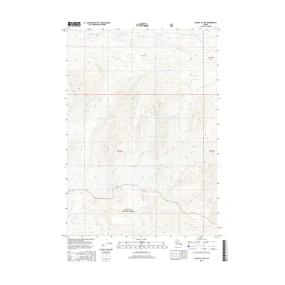
2016 Map of Valdez A-3 NW
USGS Topo · Published 2016About this map
Chugach National Forest occupies a significant portion of this terrain in the Unorganized Borough, where the southern reaches of the map are defined by the steep drainage basins of Cleave Cr. To the north, the Tiekel River flows through the landscape, joined by its tributary Thunder Cr. This 2016 survey illustrates the high-elevation topography of the Chugach Mountains, highlighting the complex network of glacial-fed streams and ridgelines that characterize this wilderness. The absence of roads or permanent settlements underscores the area's primary use for forest management and backcountry navigation, providing a clear record of the hydrography and land boundaries of the t8s r2e and t7s r2e townships.
Find a feature on this map
8 named features on this map. Tap any name to fly to it.
Don’t see what you’re looking for? This feature index may not catch every label — zoom into the map to look around manually.
Map Details
Editions of this 2016 Valdez A-3 NW Map
This is the sole edition of this map. No revisions or reprints were ever made.
Other maps of this area

1950 · Valdez A-3
USGS Topo · 1:63,360

1951 · Valdez B-3
USGS Topo · 1:63,360

1951 · Valdez B-4
USGS Topo · 1:63,360

1952 · Valdez
USGS Topo · 1:250,000

1953 · Valdez B-4
USGS Topo · 1:63,360

1953 · Valdez A-4
USGS Topo · 1:63,360

1953 · Valdez A-3
USGS Topo · 1:63,360

1960 · Valdez
USGS Topo · 1:250,000
1994 · Valdez A-3
USGS Topo · 1:63,360
1994 · Valdez A-4
USGS Topo · 1:63,360