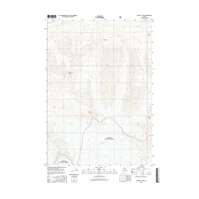
2016 Map of Valdez A-4 NE
USGS Topo · Published 2016About this map
Cleave Creek Glacier dominates the southern reaches of this landscape within the Chugach National Forest, illustrating the high-altitude ice fields of the Unorganized Borough. The topography is defined by the steep elevation changes surrounding Mt Billy Mitchell, which stands as a prominent landmark in the western portion of the quadrangle. In the northern sections, the drainage patterns of the Tsina River and Tiekel River carve through the terrain, indicating the primary watercourses that shape these valleys. This 2016 survey captures the area's transition between massive glacial ice and the river systems that carry meltwater away from the peaks.
Find a feature on this map
7 named features on this map. Tap any name to fly to it.
Don’t see what you’re looking for? This feature index may not catch every label — zoom into the map to look around manually.
Map Details
Editions of this 2016 Valdez A-4 NE Map
This is the sole edition of this map. No revisions or reprints were ever made.
Other maps of this area

1950 · Valdez A-3
USGS Topo · 1:63,360

1951 · Valdez B-3
USGS Topo · 1:63,360

1951 · Valdez B-4
USGS Topo · 1:63,360

1952 · Valdez
USGS Topo · 1:250,000

1953 · Valdez B-4
USGS Topo · 1:63,360

1953 · Valdez A-4
USGS Topo · 1:63,360

1953 · Valdez A-3
USGS Topo · 1:63,360

1960 · Valdez
USGS Topo · 1:250,000
1994 · Valdez A-3
USGS Topo · 1:63,360
1994 · Valdez A-4
USGS Topo · 1:63,360