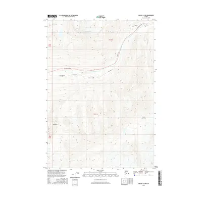
2016 Map of Valdez A-4 NW
USGS Topo · Published 2016About this map
Ted Stevens Icefield dominates the northern high country of this 2016 survey, feeding glacial meltwater into the steep drainages of the Chugach Mountains. The landscape is defined by the narrow corridor of human infrastructure that threads through the peaks, following the path of the Tsina River. Here, the modern Alaska Pipeline and the Richardson Highway run in close proximity, tracing a vital lifeline through the wilderness. To the south, the topography descends toward the Lowe River valley, while the prominent peak of Mt Diamond stands as a landmark for those navigating the western reaches of the quadrangle. The map illustrates the concentration of industrial and transport activity within an otherwise glaciated and undeveloped mountain range.
Find a feature on this map
11 named features on this map. Tap any name to fly to it.
Don’t see what you’re looking for? This feature index may not catch every label — zoom into the map to look around manually.
Map Details
Editions of this 2016 Valdez A-4 NW Map
This is the sole edition of this map. No revisions or reprints were ever made.
Other maps of this area

1951 · Valdez B-5
USGS Topo · 1:63,360

1951 · Valdez B-4
USGS Topo · 1:63,360

1952 · Valdez
USGS Topo · 1:250,000

1953 · Valdez B-4
USGS Topo · 1:63,360

1953 · Valdez A-4
USGS Topo · 1:63,360

1953 · Valdez A-5
USGS Topo · 1:63,360

1960 · Valdez
USGS Topo · 1:250,000
1994 · Valdez A-4
USGS Topo · 1:63,360

1994 · Valdez B-4
USGS Topo · 1:63,360
1995 · Valdez B-5
USGS Topo · 1:63,360