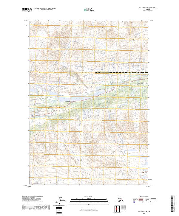
2023 Map of Valdez A-5 NE
USGS Topo · Published 2023About this map
The Richardson Highway and the Alaska Pipeline parallel each other through this corridor of the Chugach Mountains, tracing a vital transportation and energy artery. The settlement of Ptarmigan sits along this route, flanked by the steep relief of Ptarmigan Drop and the waters of the Tsina River. This map shows a landscape defined by dramatic elevation changes, where drainage systems like Ptarmigan Creek, Cascade Creek, and Small Creek flow from the surrounding peaks toward the river valley. The presence of the Thompson Pass Airport highlights the area's role as a high-altitude transit point, providing critical access to this remote interior region. The boundary between the Copper River Census Area and the Chugach Census Area crosses the northern portion of the sheet, marking a transition in regional administration.
Find a feature on this map
14 named features on this map. Tap any name to fly to it.
Don’t see what you’re looking for? This feature index may not catch every label — zoom into the map to look around manually.
Map Details
Editions of this 2023 Valdez A-5 NE Map
This is the sole edition of this map. No revisions or reprints were ever made.
Other maps of this area

1951 · Valdez B-5
USGS Topo · 1:63,360

1951 · Valdez B-4
USGS Topo · 1:63,360

1952 · Valdez
USGS Topo · 1:250,000

1953 · Valdez B-4
USGS Topo · 1:63,360

1953 · Valdez A-4
USGS Topo · 1:63,360

1953 · Valdez A-5
USGS Topo · 1:63,360

1960 · Valdez
USGS Topo · 1:250,000
1994 · Valdez A-4
USGS Topo · 1:63,360

1994 · Valdez B-4
USGS Topo · 1:63,360
1995 · Valdez B-5
USGS Topo · 1:63,360