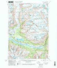
1951 Map of Valdez A-6
USGS Topo · Published 1980About this map
Glacial movement and industrial infrastructure define this landscape south of the main Valdez townsite during the mid-20th century. The Lowe River dominates the valley floor, protected by a levee near the Valdez Airport, while the Richardson Highway snakes alongside the water through the dramatic Keystone Canyon. This corridor serves as a vital artery for the Trans-Alaska Pipeline, which is shown both above ground and in underground segments.
Find a feature on this map
41 named features on this map. Tap any name to fly to it.
Don’t see what you’re looking for? This feature index may not catch every label — zoom into the map to look around manually.
Map Details
Editions of this 1951 Valdez A-6 Map
2 editions found
Other maps of this area

1948 · Cordova
USGS Topo · 1:250,000

1950 · Cordova D-7
USGS Topo · 1:63,360

1950 · Cordova D-5
USGS Topo · 1:63,360

1951 · Cordova
USGS Topo · 1:250,000

1951 · Valdez B-5
USGS Topo · 1:63,360

1951 · Cordova D-6
USGS Topo · 1:63,360

1951 · Valdez B-6
USGS Topo · 1:63,360

1951 · Valdez A-6
USGS Topo · 1:63,360

1952 · Valdez
USGS Topo · 1:250,000

1952 · Cordova D-7
USGS Topo · 1:63,360