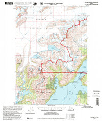
1995 Map of Valdez A-8
USGS Topo · Published 1995About this map
Chugach National Forest encompasses the majority of this coastal Alaskan landscape, where the massive Columbia Glacier and Shoup Glacier dominate the terrain. This mid-1990s revision reveals the intricate relationship between the ice and the sea, specifically around Port Valdez and the Valdez Narrows. Maritime infrastructure is carefully noted, including the USCG Radar Tower and several light stations such as the Middle Rock Light and Boat Light near Potato Point. These markings illustrate the critical importance of navigation within the Valdez Arm and Jack Bay during this era.
Find a feature on this map
39 named features on this map. Tap any name to fly to it.
Don’t see what you’re looking for? This feature index may not catch every label — zoom into the map to look around manually.
Map Details
Editions of this 1995 Valdez A-8 Map
This is the sole edition of this map. No revisions or reprints were ever made.
Other maps of this area

1948 · Cordova
USGS Topo · 1:250,000

1950 · Cordova D-7
USGS Topo · 1:63,360

1951 · Seward
USGS Topo · 1:250,000

1951 · Anchorage
USGS Topo · 1:250,000

1951 · Cordova
USGS Topo · 1:250,000

1951 · Seward D-1
USGS Topo · 1:63,360

1951 · Cordova D-8
USGS Topo · 1:63,360

1952 · Valdez
USGS Topo · 1:250,000

1952 · Seward D-1
USGS Topo · 1:63,360

1952 · Cordova D-8
USGS Topo · 1:63,360