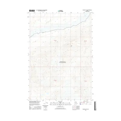
2016 Map of Valdez B-2 SW
USGS Topo · Published 2016About this map
The Copper River dominates the northern landscape of this region, serving as a primary corridor through the high-altitude terrain of the Chugach and Wrangell ranges. This 2016 survey highlights a section of Wrangell-Saint Elias National Park, where the river’s braided channels transition through the glacial valley. The topographical detail reveals the sharp rise of Spirit Mtn, which towers over the eastern bank of the river, marking a significant landmark for those navigating this roadless wilderness. To the northwest, the Uranatina River feeds into the main flow, illustrating the complex hydrology of the Unorganized Borough. This map is particularly valuable for its contemporary elevation data and modern boundary delineations within the largest national park in the United States, providing a clear record of the glacial and fluvial landscape before continued environmental shifts.
Find a feature on this map
8 named features on this map. Tap any name to fly to it.
Don’t see what you’re looking for? This feature index may not catch every label — zoom into the map to look around manually.
Map Details
Editions of this 2016 Valdez B-2 SW Map
This is the sole edition of this map. No revisions or reprints were ever made.
Other maps of this area

1950 · Valdez A-3
USGS Topo · 1:63,360

1951 · Valdez B-2
USGS Topo · 1:63,360

1951 · Valdez B-3
USGS Topo · 1:63,360

1951 · Valdez A-2
USGS Topo · 1:63,360

1952 · Valdez
USGS Topo · 1:250,000

1953 · Valdez A-3
USGS Topo · 1:63,360
1957 · Valdez A-2
USGS Topo · 1:63,360

1960 · Valdez
USGS Topo · 1:250,000
1994 · Valdez A-3
USGS Topo · 1:63,360
1995 · Valdez B-3
USGS Topo · 1:63,360