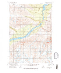
1951 Map of Valdez B-2
USGS Topo · Published 1974About this map
Taral occupies a strategic position at the confluence of the Copper River and Chitina River, serving as a focal point in this remote Alaskan interior landscape. The map records the remnant of the regional industrial history through the Railroad Grade that follows the western bank of the Copper River, a trace of the Copper River and Northwestern Railway which once moved ore from the interior to the coast. This transport corridor navigates the constricted passage of Wood Canyon, where the river narrows between steep walls.
Find a feature on this map
15 named features on this map. Tap any name to fly to it.
Don’t see what you’re looking for? This feature index may not catch every label — zoom into the map to look around manually.
Map Details
Editions of this 1951 Valdez B-2 Map
3 editions found
Other maps of this area

1950 · Valdez A-3
USGS Topo · 1:63,360

1951 · Valdez B-2
USGS Topo · 1:63,360

1951 · Valdez B-3
USGS Topo · 1:63,360

1951 · Valdez B-1
USGS Topo · 1:63,360

1951 · Valdez A-1
USGS Topo · 1:63,360

1951 · Valdez C-2
USGS Topo · 1:63,360

1951 · Valdez C-3
USGS Topo · 1:63,360

1951 · Valdez C-1
USGS Topo · 1:63,360

1951 · Valdez A-2
USGS Topo · 1:63,360

1952 · Valdez
USGS Topo · 1:250,000