
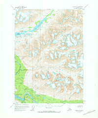
1951 Map of Valdez A-1
USGS Topo · Published 1960About this map
Glacial ice and high-altitude drainage systems dominate this mid-century survey of the Chugach Mountains interior. The Tebay Lakes and the Tebay River form a significant freshwater chain in the northern portion of the map, carving through high ridges where survey points like Vabm 5976 High mark the vertical extremes. In the southern half, the Bremner River and the Little Bremner River collect runoff from numerous unnamed glaciers, with the East Fork and Salmon Creek feeding into the wider glacial valley. The lack of roads or established trails, as noted by the Geological Survey, emphasizes the wilderness character of the region during the early 1950s. Surveyors relied on triangulation stations such as Vabm 2377 Price to chart this complex system of ice fields and silt-laden waterways near Price Creek.
Find a feature on this map
10 named features on this map. Tap any name to fly to it.
Don’t see what you’re looking for? This feature index may not catch every label — zoom into the map to look around manually.
Map Details
Editions of this 1951 Valdez A-1 Map
2 editions found
Other maps of this area

1948 · Cordova
USGS Topo · 1:250,000

1950 · McCarthy A-8
USGS Topo · 1:63,360

1950 · Bering Glacier
USGS Topo · 1:250,000

1951 · McCarthy
USGS Topo · 1:250,000

1951 · Bering Glacier
USGS Topo · 1:250,000

1951 · Cordova
USGS Topo · 1:250,000

1951 · Valdez B-2
USGS Topo · 1:63,360

1951 · Valdez B-1
USGS Topo · 1:63,360

1951 · McCarthy B-8
USGS Topo · 1:63,360

1951 · Valdez A-2
USGS Topo · 1:63,360