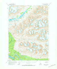
1951 Map of Valdez A-1
USGS Topo · Published 1973About this map
Tebay Lakes dominate the northern terrain of this remote Alaskan wilderness, forming a tiered chain of glacial waters connected by the Tebay River. The landscape is defined by its dramatic hydrography, where the Upper Tebay Lake, Middle Tebay Lake, and Lower Tebay Lake descend toward the valley floor. To the south, the massive drainage system of the Bremner River and its tributary, the Little Bremner River, carves through the southern quadrant. This 1951 survey reveals a landscape almost entirely devoid of human infrastructure, focusing instead on the complex network of mountain streams like Porcupine Creek, Salmon Creek, and Price Creek. The drainage patterns, particularly around the East Fork, illustrate the unbridled flow of water across a high-elevation environment before modern encroachment or development altered the natural state of these watersheds.
Find a feature on this map
11 named features on this map. Tap any name to fly to it.
Don’t see what you’re looking for? This feature index may not catch every label — zoom into the map to look around manually.
Map Details
Editions of this 1951 Valdez A-1 Map
2 editions found
Other maps of this area

1948 · Cordova
USGS Topo · 1:250,000

1950 · McCarthy A-8
USGS Topo · 1:63,360

1950 · Bering Glacier
USGS Topo · 1:250,000

1951 · McCarthy
USGS Topo · 1:250,000

1951 · Bering Glacier
USGS Topo · 1:250,000

1951 · Cordova
USGS Topo · 1:250,000

1951 · Valdez B-2
USGS Topo · 1:63,360

1951 · Valdez B-1
USGS Topo · 1:63,360

1951 · Valdez A-1
USGS Topo · 1:63,360

1951 · McCarthy B-8
USGS Topo · 1:63,360