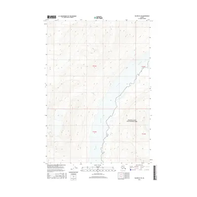
2016 Map of Valdez B-3 SE
USGS Topo · Published 2016About this map
Copper River flows prominently through this Alaskan landscape, cutting a deep valley between steep mountain ridges as it travels south. This 2016 survey illustrates a largely untouched wilderness within the Wrangell-Saint Elias National Park, where the river serves as the primary drainage for the surrounding peaks. High-elevation glacial features are evident, such as the drainage from Cirque Cr, which feeds into the larger river system from the west. The topography is defined by sharp contour lines that reach elevations over 5,000 feet, highlighting the dramatic vertical rise from the riverbanks. The mapping of this area reflects the continued preservation of one of the nation's largest protected wilderness areas, emphasizing the raw natural hydrology and glaciated terrain of the region.
Find a feature on this map
3 named features on this map. Tap any name to fly to it.
Don’t see what you’re looking for? This feature index may not catch every label — zoom into the map to look around manually.
Map Details
Editions of this 2016 Valdez B-3 SE Map
This is the sole edition of this map. No revisions or reprints were ever made.
Other maps of this area

1950 · Valdez A-3
USGS Topo · 1:63,360

1951 · Valdez B-2
USGS Topo · 1:63,360

1951 · Valdez B-3
USGS Topo · 1:63,360

1951 · Valdez A-2
USGS Topo · 1:63,360

1952 · Valdez
USGS Topo · 1:250,000

1953 · Valdez A-3
USGS Topo · 1:63,360
1957 · Valdez A-2
USGS Topo · 1:63,360

1960 · Valdez
USGS Topo · 1:250,000
1994 · Valdez A-3
USGS Topo · 1:63,360
1995 · Valdez B-3
USGS Topo · 1:63,360