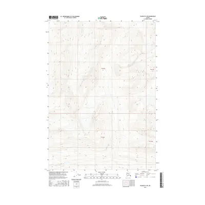
2016 Map of Valdez B-3 SW
USGS Topo · Published 2016About this map
Ernestine Cr is the primary waterway threading through this remote Alaskan landscape in the unorganized borough. This 2016 survey emphasizes the complex topography of the region, captured with an 80-foot contour interval to illustrate the steep elevation changes. The area is defined by its extensive public land survey system grid, including portions of T6s R2e, T6s R3e, T7s R2e, and T7s R3e. This map documents a largely untouched wilderness where natural drainage patterns and high-altitude terrain dominate, providing a precise look at the geography before further environmental shifts or modern infrastructure developments in the region.
Find a feature on this map
5 named features on this map. Tap any name to fly to it.
Don’t see what you’re looking for? This feature index may not catch every label — zoom into the map to look around manually.
Map Details
Editions of this 2016 Valdez B-3 SW Map
This is the sole edition of this map. No revisions or reprints were ever made.
Other maps of this area

1950 · Valdez A-3
USGS Topo · 1:63,360

1951 · Valdez B-3
USGS Topo · 1:63,360

1951 · Valdez B-4
USGS Topo · 1:63,360

1952 · Valdez
USGS Topo · 1:250,000

1953 · Valdez B-4
USGS Topo · 1:63,360

1953 · Valdez A-4
USGS Topo · 1:63,360

1953 · Valdez A-3
USGS Topo · 1:63,360

1960 · Valdez
USGS Topo · 1:250,000
1994 · Valdez A-3
USGS Topo · 1:63,360
1994 · Valdez A-4
USGS Topo · 1:63,360