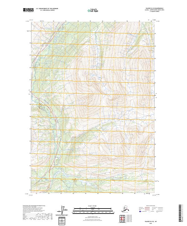
2023 Map of Valdez B-4 SE
USGS Topo · Published 2023About this map
The Alaska Pipeline and the Richardson Highway parallel each other through this mountain passage, illustrating the heavy infrastructure required for transit and energy in this part of Alaska. The landscape is defined by the confluence of major glacial-fed drainages, notably the Tsina River and the Tiekel River, which carve deep paths through the high-elevation terrain. This corridor serves as a vital artery for the state's interior, following the natural grades established by watercourses like Ts'akae Creek and Stuart Creek.
Find a feature on this map
12 named features on this map. Tap any name to fly to it.
Don’t see what you’re looking for? This feature index may not catch every label — zoom into the map to look around manually.
Map Details
Editions of this 2023 Valdez B-4 SE Map
This is the sole edition of this map. No revisions or reprints were ever made.
Other maps of this area

1950 · Valdez A-3
USGS Topo · 1:63,360

1951 · Valdez B-3
USGS Topo · 1:63,360

1951 · Valdez B-4
USGS Topo · 1:63,360

1952 · Valdez
USGS Topo · 1:250,000

1953 · Valdez B-4
USGS Topo · 1:63,360

1953 · Valdez A-4
USGS Topo · 1:63,360

1953 · Valdez A-3
USGS Topo · 1:63,360

1960 · Valdez
USGS Topo · 1:250,000
1994 · Valdez A-3
USGS Topo · 1:63,360
1994 · Valdez A-4
USGS Topo · 1:63,360