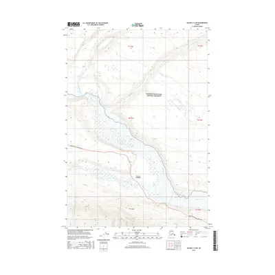
2016 Map of Valdez C-2 NW
USGS Topo · Published 2016About this map
Lower Tonsina sits at the confluence of glacial waters in this 2016 survey of the Copper River basin. The landscape is defined by the braided path of the Copper River, which receives the Tonsina River and Hundell Cr from the west. Much of the eastern terrain lies within the protected boundaries of the Wrangell-Saint Elias National Preserve, where the Chetaslina River and Cheshnina River flow toward the primary river valley. Human infrastructure is concentrated along the Edgerton Hwy/McCarthy Rd, a vital corridor providing access through the Unorganized Borough. This map captures the intersection of wilderness preservation and the thin ribbon of transport that connects remote Alaskan settlements, illustrating how the natural drainage systems dictate the placement of roads and small communities like Lower Tonsina.
Find a feature on this map
14 named features on this map. Tap any name to fly to it.
Don’t see what you’re looking for? This feature index may not catch every label — zoom into the map to look around manually.
Map Details
Editions of this 2016 Valdez C-2 NW Map
This is the sole edition of this map. No revisions or reprints were ever made.
Other maps of this area

1951 · Valdez C-2
USGS Topo · 1:63,360

1951 · Valdez C-3
USGS Topo · 1:63,360

1952 · Valdez
USGS Topo · 1:250,000

1953 · Valdez C-2
USGS Topo · 1:63,360

1953 · Valdez C-3
USGS Topo · 1:63,360

1958 · Valdez D-3
USGS Topo · 1:63,360

1959 · Valdez D-2
USGS Topo · 1:63,360

1960 · Valdez
USGS Topo · 1:250,000
1996 · Valdez D-3
USGS Topo · 1:63,360

1996 · Valdez C-2
USGS Topo · 1:63,360