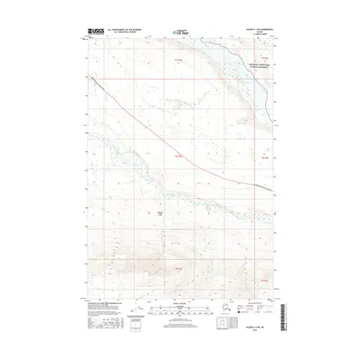
2016 Map of Valdez C-3 NE
USGS Topo · Published 2016About this map
Kenny Lake serves as the central settlement point in this interior Alaskan landscape, situated along the critical transit corridor of the Edgerton Hwy/McCarthy Rd. The topography is defined by the significant drainage systems of the Copper River to the northeast and the Tonsina River flowing through the central portion of the quadrangle. These waterways historically dictated travel and subsistence patterns in the Copper River Basin. To the east, the boundary of the Wrangell-Saint Elias National Preserve marks a transition into protected wilderness. The map illustrates the sparse but vital infrastructure of the Unorganized Borough, where the road network provides the primary link between isolated settlements and the broader Alaskan interior.
Find a feature on this map
11 named features on this map. Tap any name to fly to it.
Don’t see what you’re looking for? This feature index may not catch every label — zoom into the map to look around manually.
Map Details
Editions of this 2016 Valdez C-3 NE Map
This is the sole edition of this map. No revisions or reprints were ever made.
Other maps of this area

1951 · Valdez C-2
USGS Topo · 1:63,360

1951 · Valdez C-3
USGS Topo · 1:63,360

1952 · Valdez
USGS Topo · 1:250,000

1953 · Valdez C-2
USGS Topo · 1:63,360

1953 · Valdez C-3
USGS Topo · 1:63,360

1958 · Valdez D-3
USGS Topo · 1:63,360

1959 · Valdez D-2
USGS Topo · 1:63,360

1960 · Valdez
USGS Topo · 1:250,000
1996 · Valdez D-3
USGS Topo · 1:63,360

1996 · Valdez C-2
USGS Topo · 1:63,360