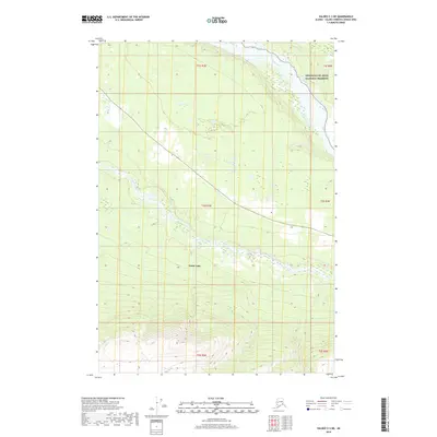
2019 Map of Valdez C-3 NE
USGS Topo · Published 2019About this map
Kenny Lake marks a pocket of settlement within this landscape of glacial valleys and river systems in the Copper River basin. The terrain is defined by the prominent course of the Copper River as it flows along the eastern boundary, joined by the Tonsina River winding through the central portion of the quadrangle. This area serves as a gateway to the Wrangell-St. Elias National Preserve, where the elevation shifts from river flats to the rising foothills. Route 10 provides the primary transit corridor, cutting diagonally across the map and linking the community of Kenny Lake to the broader regional network during this period of the early 21st century.
Find a feature on this map
11 named features on this map. Tap any name to fly to it.
Don’t see what you’re looking for? This feature index may not catch every label — zoom into the map to look around manually.
Map Details
Editions of this 2019 Valdez C-3 NE Map
This is the sole edition of this map. No revisions or reprints were ever made.
Other maps of this area

1951 · Valdez C-2
USGS Topo · 1:63,360

1951 · Valdez C-3
USGS Topo · 1:63,360

1952 · Valdez
USGS Topo · 1:250,000

1953 · Valdez C-2
USGS Topo · 1:63,360

1953 · Valdez C-3
USGS Topo · 1:63,360

1958 · Valdez D-3
USGS Topo · 1:63,360

1959 · Valdez D-2
USGS Topo · 1:63,360

1960 · Valdez
USGS Topo · 1:250,000
1996 · Valdez D-3
USGS Topo · 1:63,360

1996 · Valdez C-2
USGS Topo · 1:63,360