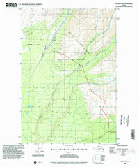
1996 Map of Valdez D-2
USGS Topo · Published 2002About this map
Wrangell-Saint Elias National Preserve and the adjacent Wrangell-Saint Elias Wilderness dominate this Alaskan interior landscape, defined by a complex network of glacial river systems. The Dadina River and Chetaslina River cut through the terrain, with the latter joined by its significant East Fork. These braided waterways, including the Chichokna River and Cheshnina River, illustrate the dynamic hydrological patterns of the Copper River Meridian. Human presence is sparse, represented by a remote Landing Strip in the northeast near Sheep Gulch. This 1990s-era data reflects a landscape managed for conservation, where the Wilderness Boundary and the survey Base Line provide the only formal divisions across the vast, roadless expanse of the Valdez D-2 quadrangle.
Find a feature on this map
12 named features on this map. Tap any name to fly to it.
Don’t see what you’re looking for? This feature index may not catch every label — zoom into the map to look around manually.
Map Details
Editions of this 1996 Valdez D-2 Map
This is the sole edition of this map. No revisions or reprints were ever made.
Other maps of this area

1951 · Gulkana
USGS Topo · 1:250,000

1951 · Valdez C-2
USGS Topo · 1:63,360

1951 · Valdez C-3
USGS Topo · 1:63,360

1951 · Valdez C-1
USGS Topo · 1:63,360

1952 · Valdez
USGS Topo · 1:250,000

1953 · Valdez C-2
USGS Topo · 1:63,360

1953 · Valdez C-3
USGS Topo · 1:63,360

1953 · Valdez C-1
USGS Topo · 1:63,360

1958 · Valdez D-3
USGS Topo · 1:63,360

1959 · Valdez D-2
USGS Topo · 1:63,360