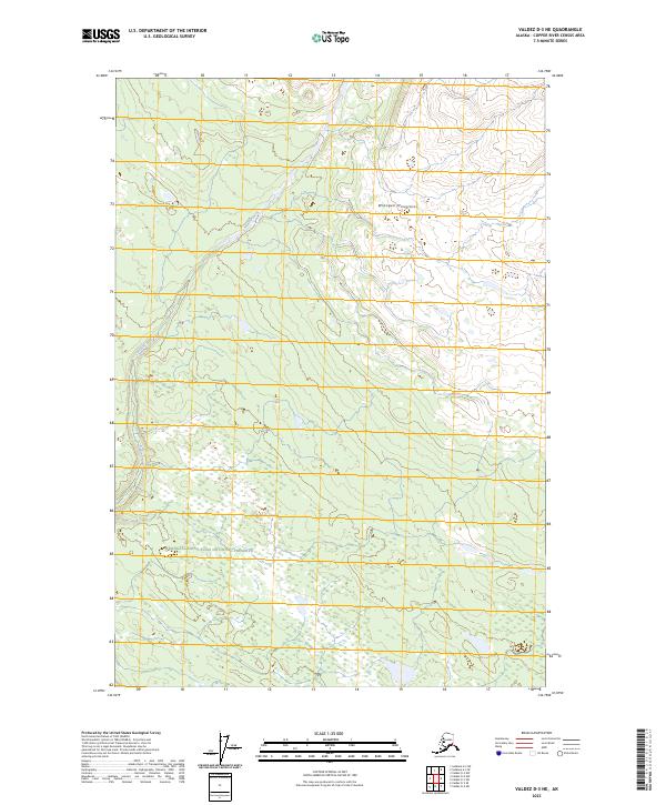
2023 Map of Valdez D-3 NE
USGS Topo · Published 2023About this map
The Wrangell Mountains dominate the northeastern portion of this survey, defining a landscape of glacial hydrology and protected wilderness. Flowing from these heights, the Nadina River cuts through the western sections, its course and tributaries shaping the drainage patterns of the Copper River Census Area. The map highlights the transition between two major federal land designations, where the Wrangell-St. Elias Wilderness meets the Wrangell-Saint Elias National Preserve. This area reflects the modern management of one of the largest protected ecosystems in North America, documented here with high-resolution topographic precision. The absence of roads or established settlements emphasizes the character of this terrain as a strictly preserved natural corridor for the river and its surrounding mountain peaks.
Find a feature on this map
10 named features on this map. Tap any name to fly to it.
Don’t see what you’re looking for? This feature index may not catch every label — zoom into the map to look around manually.
Map Details
Editions of this 2023 Valdez D-3 NE Map
This is the sole edition of this map. No revisions or reprints were ever made.
Other maps of this area

1951 · Gulkana
USGS Topo · 1:250,000

1952 · Valdez
USGS Topo · 1:250,000

1958 · Valdez D-3
USGS Topo · 1:63,360

1959 · Valdez D-2
USGS Topo · 1:63,360
1959 · Gulkana A-2
USGS Topo · 1:63,360

1959 · Gulkana
USGS Topo · 1:250,000

1960 · Valdez
USGS Topo · 1:250,000

1965 · Gulkana
USGS Topo · 1:250,000
1996 · Valdez D-3
USGS Topo · 1:63,360
1996 · Valdez D-2
USGS Topo · 1:63,360