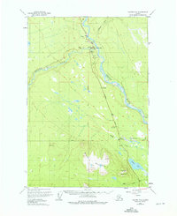
1949 Map of Valdez D-4
USGS Topo · Published 1975About this map
Copper Center sits at the vital confluence of the Klutina River and the Copper River, serving as a critical junction for interior travel in the years following World War II. The landscape is defined by the intersection of early Alaskan infrastructure and formidable natural terrain, where the Richardson Highway and Old Edgerton Highway provide the primary terrestrial links through the river valleys. A specialized Astro Station (1027) and numerous survey markers like Willow Creek North Base indicate the intense mapping efforts required to document this region. To the south, the massive forms of Stuck Mountain and Willow Mountain loom over a network of glacial waters including Willow Lake and Willow Creek, while a local Landing Strip and Gravel Pit near the settlement highlight the modest industrial and logistical footprint of the era.
Find a feature on this map
28 named features on this map. Tap any name to fly to it.
Don’t see what you’re looking for? This feature index may not catch every label — zoom into the map to look around manually.
Map Details
Editions of this 1949 Valdez D-4 Map
4 editions found
Other maps of this area

1948 · Valdez D-5
USGS Topo · 1:63,360

1949 · Gulkana A-3
USGS Topo · 1:63,360

1949 · Valdez D-4
USGS Topo · 1:63,360

1951 · Valdez D-5
USGS Topo · 1:63,360

1951 · Gulkana
USGS Topo · 1:250,000

1951 · Gulkana A-4
USGS Topo · 1:63,360

1951 · Valdez C-3
USGS Topo · 1:63,360

1951 · Valdez C-4
USGS Topo · 1:63,360

1951 · Valdez C-5
USGS Topo · 1:63,360

1952 · Gulkana A-3
USGS Topo · 1:63,360