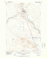
1952 Map of Valdez D-4
USGS Topo · Published 1952About this map
Copper Center serves as the focal point of this Alaskan landscape, situated at the confluence where the Klutina River meets the Copper River. The map reflects a period of institutional transition, marked by several decommissioned government sites including the U S School Reserve (Abandoned), the U S Mil Res (Abandoned), and the U S Experiment Station Reserve (Abandoned). These administrative footprints suggest an era of early 20th-century development that had already begun to shift by the late 1940s.
Find a feature on this map
26 named features on this map. Tap any name to fly to it.
Don’t see what you’re looking for? This feature index may not catch every label — zoom into the map to look around manually.
Map Details
Editions of this 1952 Valdez D-4 Map
2 editions found

Other maps of this area

1948 · Valdez D-5
USGS Topo · 1:63,360

1949 · Gulkana A-3
USGS Topo · 1:63,360

1949 · Valdez D-4
USGS Topo · 1:63,360

1951 · Valdez D-5
USGS Topo · 1:63,360

1951 · Gulkana
USGS Topo · 1:250,000

1951 · Gulkana A-4
USGS Topo · 1:63,360

1951 · Valdez C-3
USGS Topo · 1:63,360

1951 · Valdez C-4
USGS Topo · 1:63,360

1951 · Valdez C-5
USGS Topo · 1:63,360

1952 · Gulkana A-3
USGS Topo · 1:63,360