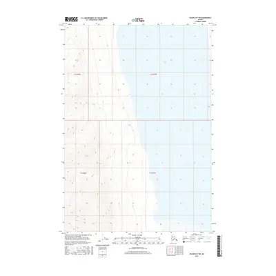
2016 Map of Valdez D-7 SW
USGS Topo · Published 2016About this map
Tazlina Lake dominates the eastern half of this terrain in the Unorganized Borough, where glacial waters fill a deep basin surrounded by high-altitude topography. The map illustrates a dramatic landscape transition, with the massive water body situated at the foot of steep western slopes that rise sharply from the shoreline. This 2016 survey documents the vast, uninhabited character of the region, defined by the Public Land Survey System grids of t1n r8w, t1n r7w, t1s r8w, and t1s r7w. The absence of roads, buildings, or named settlements highlights the primitive nature of this Alaskan interior, where the natural hydrography and elevation contours are the primary markers of the land. Researchers can observe the intricate shoreline of the lake and the numerous small drainage systems that feed into it from the surrounding highlands.
Find a feature on this map
5 named features on this map. Tap any name to fly to it.
Don’t see what you’re looking for? This feature index may not catch every label — zoom into the map to look around manually.
Map Details
Editions of this 2016 Valdez D-7 SW Map
This is the sole edition of this map. No revisions or reprints were ever made.
Other maps of this area

1949 · Valdez D-8
USGS Topo · 1:63,360

1949 · Valdez D-7
USGS Topo · 1:63,360

1951 · Valdez D-7
USGS Topo · 1:63,360

1952 · Valdez D-8
USGS Topo · 1:63,360

1952 · Valdez
USGS Topo · 1:250,000

1960 · Valdez C-7
USGS Topo · 1:63,360

1960 · Valdez C-8
USGS Topo · 1:63,360

1960 · Valdez
USGS Topo · 1:250,000
1993 · Valdez D-7
USGS Topo · 1:63,360
1993 · Valdez D-8
USGS Topo · 1:63,360