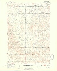
1951 Map of Vale
USGS Topo · Published 1953About this map
The settlement of Vale serves as the focal point for this early 1950s survey of the Butte and Meade County border. This region of the Highland territory is defined by a complex network of irrigation infrastructure designed to support agricultural development in the Missouri River Basin. Water management is meticulously documented through features like the South Canal, Baldwin Lateral, and Shaw Lateral, which snake across the landscape near Whitewood Creek. The map records a rural educational system in transition, noting both the Fairview Sch and Cottonwood Sch, while the Riggs Sch (Abandoned) reflects shifting population patterns. Transportation and local history are anchored by the Chicago and North Western railroad corridor and the Wagner Historical Monument near Sulphur Spring.
Find a feature on this map
19 named features on this map. Tap any name to fly to it.
Don’t see what you’re looking for? This feature index may not catch every label — zoom into the map to look around manually.
Map Details
Editions of this 1951 Vale Map
3 editions found

Other maps of this area

1893 · Rapid
USGS Topo · 1:125,000

1894 · Deadwood
USGS Topo · 1:125,000

1898 · Rapid
USGS Topo · 1:125,000

1899 · Sturgis
USGS Topo · 1:62,500

1901 · Deadwood
USGS Topo · 1:125,000

1903 · Rapid
USGS Topo · 1:125,000

1905 · Saint Onge
USGS Topo · 1:62,500

1906 · Vale
USGS Topo · 1:62,500

1907 · Belle Fourche
USGS Topo · 1:125,000

1913 · Newell
USGS Topo · 1:125,000