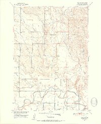
1951 Map of Vale NE
USGS Topo · Published 1953About this map
The Belle Fourche River snakes through the southern reaches of this Butte County landscape, defining the local topography just east of Vale. This 1951 survey highlights the intricate irrigation network developed as part of the Missouri River Basin project, including the North Spoil Bank Canal, Antelope Lateral, and Wood Lateral. These man-made watercourses reflect the agricultural transformation of the semi-arid plains during the mid-century era.
Find a feature on this map
23 named features on this map. Tap any name to fly to it.
Don’t see what you’re looking for? This feature index may not catch every label — zoom into the map to look around manually.
Map Details
Editions of this 1951 Vale NE Map
4 editions found
Other maps of this area

1906 · Vale
USGS Topo · 1:62,500

1913 · Newell
USGS Topo · 1:125,000

1951 · Volunteer
USGS Topo · 1:24,000

1951 · Vale
USGS Topo · 1:24,000

1951 · Vale SE
USGS Topo · 1:24,000

1951 · Newell
USGS Topo · 1:24,000

1951 · Vale NE
USGS Topo · 1:24,000

1951 · Vale
USGS Topo · 1:62,500

1953 · Rapid City
USGS Topo · 1:250,000

1957 · Rapid City
USGS Topo · 1:250,000