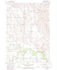
1951 Map of Vale NE
USGS Topo · Published 1980About this map
The Belle Fourche River snakes across this South Dakota landscape, defining the character of the river basin as it appeared in the mid-20th century. The settlement of Vale serves as the focal point for a complex network of irrigation infrastructure designed for the development of the Missouri River Basin. This system includes the North Canal and a detailed web of naming-specific lateral canals such as the Antelope Lateral, Town Site Lateral, Richards Lateral, and Wood Lateral. Numerous tributaries feed into the river system, including Horse Creek, Willow Creek, and Deer Creek. The presence of several spoil banks and underground features along the canal routes highlights the engineered nature of the terrain, where water management was essential for local agriculture and settlement growth.
Find a feature on this map
16 named features on this map. Tap any name to fly to it.
Don’t see what you’re looking for? This feature index may not catch every label — zoom into the map to look around manually.
Map Details
Editions of this 1951 Vale NE Map
4 editions found
Other maps of this area

1906 · Vale
USGS Topo · 1:62,500

1913 · Newell
USGS Topo · 1:125,000

1951 · Volunteer
USGS Topo · 1:24,000

1951 · Vale
USGS Topo · 1:24,000

1951 · Vale SE
USGS Topo · 1:24,000

1951 · Newell
USGS Topo · 1:24,000

1951 · Vale NE
USGS Topo · 1:24,000

1951 · Vale
USGS Topo · 1:62,500

1953 · Rapid City
USGS Topo · 1:250,000

1957 · Rapid City
USGS Topo · 1:250,000