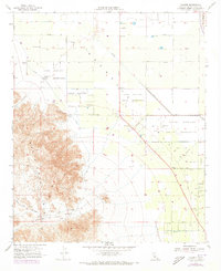
1956 Map of Valerie
USGS Topo · Published 1973About this map
The Torres Martinez Indian Reservation dominates this desert landscape, where the flatlands of the Coachella Valley meet the steep eastern slopes of the Santa Rosa Mountains. In the mid-20th century, this area preserved significant archaeological markers, including Petroglyphs and Early Indian Fish Traps near the shoreline of the ancient Cahuilla lakebed. The settlement pattern is defined by agricultural clusters and desert outposts like Valerie, Martinez, and 100 Palms, serviced by a network of wells and a prominent pipeline running through the valley floor. To the north, the Thermal Airport and the Coachella Valley Stormwater Channel represent the growing regional infrastructure. Local heritage is further marked by the Toro Cem, Martinez Cemetery, and the Torres (Site), providing a detailed record of communal and cultural sites before more modern developments altered the valley floor.
Find a feature on this map
21 named features on this map. Tap any name to fly to it.
Don’t see what you’re looking for? This feature index may not catch every label — zoom into the map to look around manually.
Map Details
Editions of this 1956 Valerie Map
4 editions found
Other maps of this area

1904 · Indio
USGS Topo · 1:125,000

1931 · Vallecito
USGS Topo · 1:125,000

1941 · Toro Peak
USGS Topo · 1:62,500

1941 · Clark Lake
USGS Topo · 1:62,500

1941 · Coachella
USGS Topo · 1:62,500

1942 · Agua Dulce
USGS Topo · 1:62,500

1942 · Clark Lake
USGS Topo · 1:62,500

1943 · Vallecito
USGS Topo · 1:125,000

1943 · Coachella
USGS Topo · 1:62,500

1944 · Agua Dulce
USGS Topo · 1:62,500