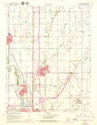
1960 Map of Valley Center
USGS Topo · Published 1979About this map
The Arkansas River and its accompanying Wichita-Valley Center Floodway dominate the southwestern landscape of this Sedgwick County region, illustrating a mid-century infrastructure response to the plains' hydrology. While Wichita expands from the south, smaller communities like Valley Center and Park City maintain distinct footprints, connected by an intricate web of industrial and religious landmarks. Local history is anchored by rural centers such as Sunnydale and the now-vanished identity of Spastieville, while the landscape is dotted with community hubs like Hillcrest Ch Cem and Keechi Center Sch.
Find a feature on this map
45 named features on this map. Tap any name to fly to it.
Don’t see what you’re looking for? This feature index may not catch every label — zoom into the map to look around manually.
Map Details
Editions of this 1960 Valley Center Map
4 editions found
Other maps of this area

1889 · Wichita
USGS Topo · 1:125,000

1894 · Wichita
USGS Topo · 1:125,000

1941 · Maize
USGS Topo · 1:31,680

1941 · Valley Center
USGS Topo · 1:31,680

1942 · Valley Center
USGS Topo · 1:31,680

1942 · Maize
USGS Topo · 1:31,680

1943 · Wichita West
USGS Topo · 1:31,680

1943 · Wichita East
USGS Topo · 1:31,680

1945 · Andover
USGS Topo · 1:31,680

1955 · Greenwich
USGS Topo · 1:24,000