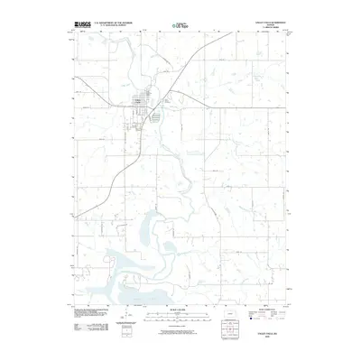
2009 Map of Valley Falls
USGS Topo · Published 2009About this map
The Valley Falls townsite sits at a significant bend in the Delaware River, where the waterway transitions from a meandering river valley into the northern reaches of Perry Lake. This 2009 survey reveals the community's established layout, centered around the Valley Falls Post Office and a grid of streets including Elm St and Sycamore St. The area's local history is anchored by several burial grounds, including Saint Marys Cemetery to the east and the adjacent Farrar Cemetery and Rose Hill Cemetery to the south. The surrounding landscape is defined by an extensive drainage network, with Brush Creek, Rock Creek, and Walnut Creek feeding into the main river channel. The map provides a detailed view of rural Jefferson County infrastructure, tracing routes like Blue Mound Rd and Headwater Rd as they navigate the creek-carved terrain above the reservoir.
Find a feature on this map
46 named features on this map. Tap any name to fly to it.
Don’t see what you’re looking for? This feature index may not catch every label — zoom into the map to look around manually.
Map Details
Editions of this 2009 Valley Falls Map
This is the sole edition of this map. No revisions or reprints were ever made.
Other maps of this area

1886 · Oskaloosa
USGS Topo · 1:125,000

1888 · Oskaloosa
USGS Topo · 1:125,000

1889 · Topeka
USGS Topo · 1:125,000

1894 · Oskaloosa
USGS Topo · 1:125,000

1894 · Topeka
USGS Topo · 1:125,000

1950 · Kansas City
USGS Topo · 1:250,000
1951 · Oskaloosa
USGS Topo · 1:24,000

1951 · Ozawkie
USGS Topo · 1:24,000
1952 · Meriden
USGS Topo · 1:24,000

1954 · Kansas City
USGS Topo · 1:250,000