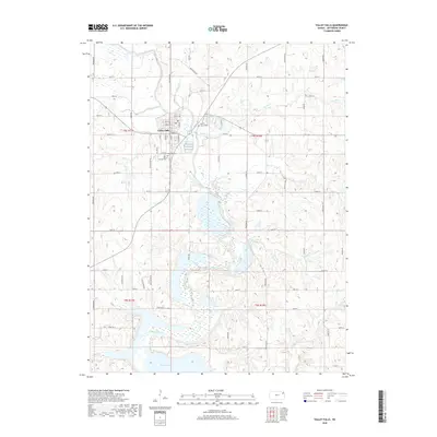
2018 Map of Valley Falls
USGS Topo · Published 2018About this map
Valley Falls serves as the central hub of this Jefferson County landscape, situated at the confluence of several major waterways and an organized grid of section roads. The northern reach of Perry Lake dominates the southern half of the map, where the Delaware River feeds into the reservoir across a wide floodplain marked by numerous wetlands. The surrounding terrain is dissected by numerous named tributaries, including Brush Cr, Rock Cr, and Fishpond Cr, which define the local drainage patterns around prominent elevations like Blue Mound.
Find a feature on this map
56 named features on this map. Tap any name to fly to it.
Don’t see what you’re looking for? This feature index may not catch every label — zoom into the map to look around manually.
Map Details
Editions of this 2018 Valley Falls Map
This is the sole edition of this map. No revisions or reprints were ever made.
Other maps of this area

1886 · Oskaloosa
USGS Topo · 1:125,000

1888 · Oskaloosa
USGS Topo · 1:125,000

1889 · Topeka
USGS Topo · 1:125,000

1894 · Oskaloosa
USGS Topo · 1:125,000

1894 · Topeka
USGS Topo · 1:125,000

1950 · Kansas City
USGS Topo · 1:250,000
1951 · Oskaloosa
USGS Topo · 1:24,000

1951 · Ozawkie
USGS Topo · 1:24,000
1952 · Meriden
USGS Topo · 1:24,000

1954 · Kansas City
USGS Topo · 1:250,000