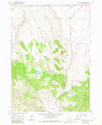
1964 Map of Valley Falls
USGS Topo · Published 1980About this map
Valley Falls serves as the primary landmark in this high-desert landscape of Lake County, Oregon, where the semi-arid terrain of Coyote Flat meets the timbered slopes of the Fremont National Forest. A complex network of water sources, including Bowersox Lake, Bobs Lake, and numerous named springs like Indian Spring, defines the local geography. The map reveals a land utilized for both recreation and ranching, evidenced by the presence of Chandler State Park and isolated outposts such as Simms Ranch and the Loveless Homestead Spring. The hydrology is particularly intricate here, with drainage through Crooked Creek and Willow Creek shaping the topography. Elevation changes are marked by features like Indian Spring Ridge, while many jeep trails provide the only access to remote points like Bull Meadow and Woodchopper Spring.
Find a feature on this map
36 named features on this map. Tap any name to fly to it.
Don’t see what you’re looking for? This feature index may not catch every label — zoom into the map to look around manually.
Map Details
Editions of this 1964 Valley Falls Map
2 editions found
Other maps of this area

1955 · Klamath Falls
USGS Topo · 1:250,000

1958 · Klamath Falls
USGS Topo · 1:250,000

1964 · Crooked Creek Valley
USGS Topo · 1:24,000

1964 · Valley Falls
USGS Topo · 1:24,000

1964 · Clover Flat
USGS Topo · 1:24,000

1964 · Big Baldy
USGS Topo · 1:24,000

1966 · Tucker Hill
USGS Topo · 1:24,000

1966 · Coglan Buttes SE
USGS Topo · 1:24,000

1968 · Crook Peak
USGS Topo · 1:24,000

1968 · Lake Abert South
USGS Topo · 1:24,000