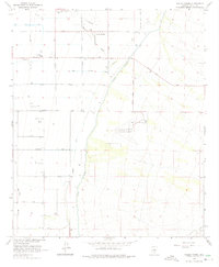
1964 Map of Valley Farms
USGS Topo · Published 1975About this map
Valley Farms and the surrounding Pinal County desert floor are defined by a complex network of irrigation and aviation infrastructure in the mid-1960s. The landscape is heavily structured by water management systems including the Casa Grande Canal, Florence Canal, and the Pima Lateral, which distribute water across a grid of roads named for local families and landmarks like Clemans Road and Kenilworth Road.
Find a feature on this map
31 named features on this map. Tap any name to fly to it.
Don’t see what you’re looking for? This feature index may not catch every label — zoom into the map to look around manually.
Map Details
Editions of this 1964 Valley Farms Map
2 editions found
Other maps of this area

1900 · Florence
USGS Topo · 1:125,000

1902 · Florence
USGS Topo · 1:125,000

1907 · Sacaton
USGS Topo · 1:62,500

1922 · Red Rock No 2
USGS Topo · 1:48,000

1922 · Signal Peak
USGS Topo · 1:62,500

1924 · Signal Peak
USGS Topo · 1:62,500

1934 · Newman Peak
USGS Topo · 1:125,000

1954 · Mesa
USGS Topo · 1:250,000

1956 · Tucson
USGS Topo · 1:250,000

1957 · Mesa
USGS Topo · 1:250,000