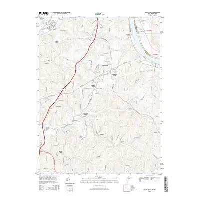
2014 Map of Valley Mills
USGS Topo · Published 2014About this map
The Ohio River flows along the northwestern boundary of this Wood County landscape, where the Mid-Ohio Valley Regional Airport serves as a modern landmark amidst a deeply dissected terrain of ridges and hollows. The area's settlement history is evidenced by numerous family and community burial grounds, including the Chichester Cem and Harper Cem. Residential clusters like Ponderosa, Rolling Hills, and Oakwood Estates illustrate the suburban development surrounding the older crossroads of Valley Mills. Moving south from the river, the topography transitions into a network of winding creeks and significant ridges, such as Ashby Ridge and Spider Ridge. Significant landmarks such as the Bethel Presbyterian Church anchor the rural landscape, while drainage basins like Worthington Cr and Gillespie Run carve through the wooded hills, reflecting the traditional Appalachian geography of the region.
Find a feature on this map
153 named features on this map. Tap any name to fly to it.
Don’t see what you’re looking for? This feature index may not catch every label — zoom into the map to look around manually.
Map Details
Editions of this 2014 Valley Mills Map
This is the sole edition of this map. No revisions or reprints were ever made.
Other maps of this area

1902 · Parkersburg
USGS Topo · 1:62,500

1904 · Parkersburg
USGS Topo · 1:62,500

1904 · Marietta
USGS Topo · 1:62,500

1906 · Elizabeth
USGS Topo · 1:62,500

1906 · Belleville
USGS Topo · 1:62,500

1924 · Belleville
USGS Topo · 1:62,500

1924 · Marietta
USGS Topo · 1:62,500

1924 · Elizabeth
USGS Topo · 1:62,500

1926 · Elizabeth
USGS Topo · 1:62,500

1926 · Belleville
USGS Topo · 1:62,500