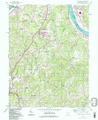
1994 Map of Valley Mills
USGS Topo · Published 1998About this map
Ohio River Islands National Wildlife Refuge and Muskingum Island dominate the river channel north of Waverly, showing the ecological character of the border between West Virginia and Ohio. This 1990s update, based on 1950s topography, reveals a landscape of ridge-top schools and country churches, such as Mt Moriah Ch and the Old Boreman Sch along the winding ridges above Worthington Creek. The interior is marked by aviation and recreation, featuring the Wood County Airport and a Drive-in Theater tucked near Valley Mills. Near the riverbank, Old Lock No 17 provides a specific point of reference for the earlier engineering of the river navigation system. The map serves as a detailed record of rural West Virginia's infrastructure, from the East Lawn Mem Cem to isolated settlements like Tallyho and Doyle.
Find a feature on this map
66 named features on this map. Tap any name to fly to it.
Don’t see what you’re looking for? This feature index may not catch every label — zoom into the map to look around manually.
Map Details
Editions of this 1994 Valley Mills Map
This is the sole edition of this map. No revisions or reprints were ever made.
Other maps of this area

1902 · Parkersburg
USGS Topo · 1:62,500

1904 · Parkersburg
USGS Topo · 1:62,500

1904 · Marietta
USGS Topo · 1:62,500

1906 · Elizabeth
USGS Topo · 1:62,500

1906 · Belleville
USGS Topo · 1:62,500

1924 · Belleville
USGS Topo · 1:62,500

1924 · Marietta
USGS Topo · 1:62,500

1924 · Elizabeth
USGS Topo · 1:62,500

1926 · Elizabeth
USGS Topo · 1:62,500

1926 · Belleville
USGS Topo · 1:62,500