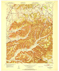
1951 Map of Valley Station
USGS Topo · Published 1951About this map
Valley Station and the neighboring community of Johnsontown serve as the primary northern hubs on this 1951 record of the area south of Louisville. The landscape is defined by the transition from the relatively flat terrain along the Illinois Central Railroad and Louisville and Nashville Railroad to the complex ridges of the Knobs. This elevation change is marked by distinctive family-named features like Moremens Hill, Samuel Hill, and Mitchell Hill.
Find a feature on this map
76 named features on this map. Tap any name to fly to it.
Don’t see what you’re looking for? This feature index may not catch every label — zoom into the map to look around manually.
Map Details
Editions of this 1951 Valley Station Map
This is the sole edition of this map. No revisions or reprints were ever made.
Other maps of this area

1907 · Louisville
USGS Topo · 1:62,500

1909 · Kosmosdale
USGS Topo · 1:48,000

1912 · Kosmosdale
USGS Topo · 1:62,500

1936 · Vine Grove
USGS Topo · 1:62,500

1943 · Vine Grove
USGS Topo · 1:62,500

1946 · Pitts Point
USGS Topo · 1:24,000

1946 · Fort Knox
USGS Topo · 1:24,000

1946 · Vine Grove
USGS Topo · 1:62,500

1949 · Shepherdsville
USGS Topo · 1:24,000

1949 · Shepherdsville
USGS Topo · 1:62,500