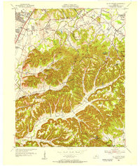
1955 Map of Valley Station
USGS Topo · Published 1956About this map
Waverly Hills and the surrounding suburban and rural landscapes of southwest Jefferson County are shown in this mid-century survey. The area transitions from the denser residential development of Valley Gardens and Johnsontown along the Dixie Highway to the steep, wooded ridges of the Knobs. This detailed topography reveals a network of small family burial grounds and community landmarks like St Jerome Ch and Sunnyside Sch.
Find a feature on this map
87 named features on this map. Tap any name to fly to it.
Don’t see what you’re looking for? This feature index may not catch every label — zoom into the map to look around manually.
Map Details
Editions of this 1955 Valley Station Map
This is the sole edition of this map. No revisions or reprints were ever made.
Other maps of this area

1907 · Louisville
USGS Topo · 1:62,500

1909 · Kosmosdale
USGS Topo · 1:48,000

1912 · Kosmosdale
USGS Topo · 1:62,500

1936 · Vine Grove
USGS Topo · 1:62,500

1943 · Vine Grove
USGS Topo · 1:62,500

1946 · Pitts Point
USGS Topo · 1:24,000

1946 · Fort Knox
USGS Topo · 1:24,000

1946 · Vine Grove
USGS Topo · 1:62,500

1949 · Shepherdsville
USGS Topo · 1:24,000

1949 · Shepherdsville
USGS Topo · 1:62,500