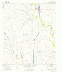
1961 Map of Valley View
USGS Topo · Published 1978About this map
Valley View serves as the primary hub of this North Texas landscape, positioned along the busy corridor of the Atchison Topeka and Santa Fe railroad. The map documents a transition in transportation and land use, showing the established rail line flanked by the newer path of Interstate 35 77. Small, dispersed settlements like Lois and Union Hill are situated among a dense network of watercourses, including Indian Creek, Duck Creek, and Spring Creek, which define the drainage patterns of the prairie.
Find a feature on this map
19 named features on this map. Tap any name to fly to it.
Don’t see what you’re looking for? This feature index may not catch every label — zoom into the map to look around manually.
Map Details
Editions of this 1961 Valley View Map
2 editions found

Other maps of this area

1902 · Gainesville
USGS Topo · 1:125,000

1943 · Gainesville
USGS Topo · 1:125,000

1954 · Sherman
USGS Topo · 1:250,000

1958 · Sherman
USGS Topo · 1:250,000

1960 · Sanger
USGS Topo · 1:24,000

1960 · Green Valley
USGS Topo · 1:24,000

1960 · Gainesville South
USGS Topo · 1:24,000

1960 · Woodbine
USGS Topo · 1:24,000

1961 · Era
USGS Topo · 1:24,000
1961 · Era SE
USGS Topo · 1:24,000