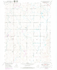
1950 Map of Valley View School
USGS Topo · Published 1979About this map
Agricultural and industrial life in Weld County defines this landscape, where a sophisticated network of irrigation canals supports high-plains farming. The Gilmore Ditch, Latham Ditch, and Neres Canal cut across the terrain, diverting water toward fields surrounding the Valley View School. These waterworks are essential to the region's productivity, feeding into landmarks like the Loloff Reservoir and managing the flow of Box Elder Creek.
Find a feature on this map
17 named features on this map. Tap any name to fly to it.
Don’t see what you’re looking for? This feature index may not catch every label — zoom into the map to look around manually.
Map Details
Editions of this 1950 Valley View School Map
2 editions found
Other maps of this area

1902 · Greeley
USGS Topo · 1:125,000

1950 · Greeley
USGS Topo · 1:24,000

1950 · Kersey
USGS Topo · 1:24,000

1950 · Tampa
USGS Topo · 1:24,000

1950 · Barnesville
USGS Topo · 1:24,000

1950 · Klug Ranch
USGS Topo · 1:24,000

1950 · Valley View School
USGS Topo · 1:24,000

1950 · Hardin
USGS Topo · 1:24,000
1950 · Milton Reservoir
USGS Topo · 1:24,000

1950 · La Salle
USGS Topo · 1:24,000