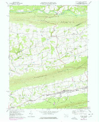
1969 Map of Valley View
USGS Topo · Published 1977About this map
The agricultural valleys and parallel ridges of central Pennsylvania define this late-1960s landscape, where the anthracite coal region transitions into the fertile Mahantango Valley. Focused on the linear settlements of Valley View and Hegins, the topography reveals a distinct pattern of ridge-top conservation and valley-floor development. Large tracts of State Game Lands No 84 and State Game Lands No 132 occupy the high ground of Line Mountain and Mahantango Mountain, while the lowlands are dense with community landmarks including Tri-Valley High Sch and St Pauls Ch. To the south, the industrial influence of the coal era is visible in the Strip Mines on Good Spring Mountain, contrasting with the quiet rural crossroads of Sacramento and Pitman further north. Several small cemeteries, such as Jacobs Cem and other unnamed plots, provide valuable points of reference for local family history research along Deep Creek and Pine Creek.
Find a feature on this map
49 named features on this map. Tap any name to fly to it.
Don’t see what you’re looking for? This feature index may not catch every label — zoom into the map to look around manually.
Map Details
Editions of this 1969 Valley View Map
2 editions found
Other maps of this area

1889 · Catawissa
USGS Topo · 1:62,500

1892 · Catawissa
USGS Topo · 1:62,500

1892 · Lykens
USGS Topo · 1:62,500

1892 · Shamokin
USGS Topo · 1:62,500

1892 · Pine Grove
USGS Topo · 1:62,500

1893 · Lykens
USGS Topo · 1:62,500

1893 · Shamokin
USGS Topo · 1:62,500

1894 · Catawissa
USGS Topo · 1:62,500

1943 · Lykens
USGS Topo · 1:62,500

1943 · Shamokin
USGS Topo · 1:62,500
Featured Places
- Hegins Township, PA
- West Cameron Township, PA
- Hubley Township, PA
- Eldred Township, PA
- East Cameron Township, PA