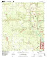
1994 Map of Valparaiso
USGS Topo · Published 1999About this map
Eglin Air Force Base dominates this Panhandle landscape, illustrating the vast military footprint in Okaloosa County during the late twentieth century. The map shows a transition from the dense, established street grids of Niceville and Valparaiso near the southern coast to the sprawling, forested interior of the reservation. Within the base boundaries, evidence of earlier aviation history is preserved in the form of decommissioned facilities like Aux Field No 5 (Abandoned) and Aux Field No 4 (Abandoned).
Find a feature on this map
33 named features on this map. Tap any name to fly to it.
Don’t see what you’re looking for? This feature index may not catch every label — zoom into the map to look around manually.
Map Details
Editions of this 1994 Valparaiso Map
This is the sole edition of this map. No revisions or reprints were ever made.
Other maps of this area

1934 · Holt
USGS Topo · 1:48,000

1934 · Niceville
USGS Topo · 1:48,000

1935 · Villa Tasso
USGS Topo · 1:48,000

1936 · Niceville
USGS Topo · 1:62,500

1937 · Holt
USGS Topo · 1:62,500

1938 · Mary Esther
USGS Topo · 1:62,500

1938 · Villa Tasso
USGS Topo · 1:62,500
1956 · Niceville
USGS Topo · 1:62,500
1956 · Fort Walton Beach
USGS Topo · 1:62,500
1956 · Holt
USGS Topo · 1:62,500