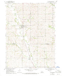
1969 Map of Valparaiso
USGS Topo · Published 1971About this map
Valparaiso serves as the central hub of this 1969 topographic study, situated at the junction of the Union Pacific railroad and the convergence of Bates Branch and Oak Creek. The landscape transition from Saunders Co into Lancaster Co is marked by a high density of rural institutions, particularly schools and cemeteries that suggest a well-established community fabric. Researchers will find several family-named landmarks such as Jensen Cem, Novotnys Sky Ranch, and Polaks Sky Ranch, indicating private land use patterns of the late 1960s.
Find a feature on this map
26 named features on this map. Tap any name to fly to it.
Don’t see what you’re looking for? This feature index may not catch every label — zoom into the map to look around manually.
Map Details
Editions of this 1969 Valparaiso Map
2 editions found
Other maps of this area

1897 · Lincoln
USGS Topo · 1:125,000

1899 · Wahoo
USGS Topo · 1:125,000

1955 · Fremont
USGS Topo · 1:250,000

1955 · Lincoln
USGS Topo · 1:250,000

1957 · Fremont
USGS Topo · 1:250,000

1957 · Lincoln
USGS Topo · 1:250,000

1958 · Fremont
USGS Topo · 1:250,000

1958 · Lincoln
USGS Topo · 1:250,000
1964 · Garland
USGS Topo · 1:24,000

1964 · Davey
USGS Topo · 1:24,000