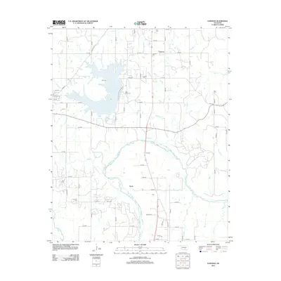
2012 Map of Vamoosa
USGS Topo · Published 2012About this map
Lake Konawa dominates the northwestern corner of this Seminole County landscape, where the waters of Jumper Cr and Wise Cem overlook the reservoir. To the south, the Canadian River meanders across the territory, bordered by the small community of Tyrola. The settlement of Vamoosa is situated to the north along the main north-south corridor, accompanied by the Vamoosa Cem. This 2012 survey reveals a rural area deeply connected to its ancestral roots, evidenced by an exceptionally high density of small family and community burial grounds including Harjo Cem, Bruner Cem, Tiger Cem, and Nash Wood Cem. The grid of section roads like n3540 RD and e1420 RD provides access to these dispersed homesteads and landmarks throughout the watershed of Negro Cr and Rock Cr.
Find a feature on this map
62 named features on this map. Tap any name to fly to it.
Don’t see what you’re looking for? This feature index may not catch every label — zoom into the map to look around manually.
Map Details
Editions of this 2012 Vamoosa Map
This is the sole edition of this map. No revisions or reprints were ever made.
Other maps of this area

1896 · Seminole and Prague
USGS Topo · 1:125,000

1901 · Stonewall
USGS Topo · 1:125,000

1907 · Maud
USGS Topo · 1:62,500

1908 · Maud
USGS Topo · 1:62,500

1954 · Oklahoma City
USGS Topo · 1:250,000

1957 · Ardmore
USGS Topo · 1:250,000

1957 · Oklahoma City
USGS Topo · 1:250,000

1958 · Sasakwa
USGS Topo · 1:24,000

1958 · Francis
USGS Topo · 1:24,000

1958 · Ada
USGS Topo · 1:24,000