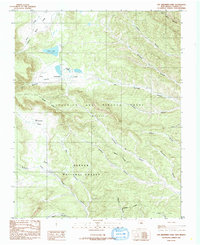
1986 Map of Van Bremmer Park
USGS Topo · Published 1986About this map
Beaubien and Miranda Grant lands dominate this high-country landscape, reflecting the complex historical land tenure of Colfax County. The area is defined by a dense network of drainages including Harry Bremmer Canyon, Broad Canyon, and Valdez Canyon, which all feed into larger systems like Ponil Creek. This 1980s-era revision shows the intersection of the Carson National Forest with private grant holdings, marked by an Indefinite Boundary that speaks to the region's surveying history.
Find a feature on this map
25 named features on this map. Tap any name to fly to it.
Don’t see what you’re looking for? This feature index may not catch every label — zoom into the map to look around manually.
Map Details
Editions of this 1986 Van Bremmer Park Map
This is the sole edition of this map. No revisions or reprints were ever made.
Other maps of this area

1954 · Raton
USGS Topo · 1:250,000

1955 · Cimarron
USGS Topo · 1:62,500

1955 · Ute Park
USGS Topo · 1:62,500

1958 · Raton
USGS Topo · 1:250,000

1962 · Ash Mountain
USGS Topo · 1:62,500

1962 · Casa Grande
USGS Topo · 1:62,500

1981 · Raton
USGS Topo · 1:100,000

1982 · Wheeler Peak
USGS Topo · 1:100,000
1986 · Vermejo Park
USGS Topo · 1:24,000
1986 · Casa Grande
USGS Topo · 1:24,000