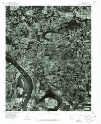
1976 Map of Van Buren
USGS Topo · Published 1978About this map
The Arkansas River serves as the dominant geographic divider in this 1970s orthophotoquad, separating the urban development of Van Buren from the northern edges of Fort Smith. This aerial perspective shows a critical moment in the region's modernization, where large-scale interstate infrastructure and industrial clearings intersect with the traditional agricultural grids of Crawford County. While the river's winding course and sandbars illustrate the natural hydrology of the valley, the concentrated layout of Van Buren and the outlying settlement of Concord highlight the mid-century expansion of residential and commercial footprints. The imagery, captured by the Soil Conservation Service, provides a literal view of land use patterns, from the densely packed city blocks to the complex interchange systems that transformed the local landscape during this era.
Find a feature on this map
4 named features on this map. Tap any name to fly to it.
Don’t see what you’re looking for? This feature index may not catch every label — zoom into the map to look around manually.
Map Details
Editions of this 1976 Van Buren Map
2 editions found
Other maps of this area

1879 · Fort Smith
USGS Topo · 1:62,500

1887 · Van Buren
USGS Topo · 1:62,500

1890 · Fort Smith
USGS Topo · 1:125,000

1898 · Winslow #4
USGS Topo · 1:62,500

1898 · Winslow #3
USGS Topo · 1:62,500

1898 · Winslow
USGS Topo · 1:125,000

1901 · Winslow
USGS Topo · 1:125,000

1906 · Lavaca
USGS Topo · 1:62,500

1943 · Fort Smith
USGS Topo · 1:125,000

1946 · Fort Smith
USGS Topo · 1:250,000