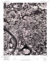
1976 Map of Van Buren
USGS Topo · Published 1987About this map
The Arkansas River dominates this mid-1970s orthophotoquad, carving a wide path through the landscape of the Arkansas River Valley. This aerial perspective, captured in early 1976, reveals the dense urban development of Van Buren as it spreads north from the river banks, contrasted with the northern tip of Fort Smith visible across the water. The imagery highlights the transition from industrial and residential clusters to the agricultural patterns of the surrounding countryside. A complex network of highways and interchanges serves the area, including the prominent route leading toward the community of Concord in the northeast. The orthophoto format provides a clear record of land use and river morphology during a period of significant regional growth.
Find a feature on this map
4 named features on this map. Tap any name to fly to it.
Don’t see what you’re looking for? This feature index may not catch every label — zoom into the map to look around manually.
Map Details
Editions of this 1976 Van Buren Map
2 editions found
Other maps of this area

1879 · Fort Smith
USGS Topo · 1:62,500

1887 · Van Buren
USGS Topo · 1:62,500

1890 · Fort Smith
USGS Topo · 1:125,000

1898 · Winslow #4
USGS Topo · 1:62,500

1898 · Winslow #3
USGS Topo · 1:62,500

1898 · Winslow
USGS Topo · 1:125,000

1901 · Winslow
USGS Topo · 1:125,000

1906 · Lavaca
USGS Topo · 1:62,500

1943 · Fort Smith
USGS Topo · 1:125,000

1946 · Fort Smith
USGS Topo · 1:250,000