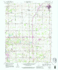
1992 Map of Van Buren
USGS Topo · Published 1995About this map
Van Buren anchors the northeastern corner of this Grant County landscape, where the town's street grid gives way to a sprawling network of agrarian townships and drainage systems. Originally surveyed in the early 1960s and updated with 1990s imagery, the map reveals a countryside defined by small rural hubs such as Landess, Hanfield, and Arcana. The drainage of the land is meticulously documented through named man-made improvements like Ludlum Ditch and Moriarity Ditch, alongside natural waterways including Hummel Creek and Walnut Creek. Cultural history is preserved through numerous rural landmarks, ranging from the Roosevelt Sch to spiritual centers like Liberty Chapel and Zion Chapel. The inclusion of Lake Wood and Lake Marion near the central Interstate corridor suggests the evolution of the local terrain to accommodate recreation and transit infrastructure in the later 20th century.
Find a feature on this map
44 named features on this map. Tap any name to fly to it.
Don’t see what you’re looking for? This feature index may not catch every label — zoom into the map to look around manually.
Map Details
Editions of this 1992 Van Buren Map
This is the sole edition of this map. No revisions or reprints were ever made.
Other maps of this area

1950 · Warren
USGS Topo · 1:24,000

1950 · Mount Etna
USGS Topo · 1:24,000

1951 · Mount Etna
USGS Topo · 1:24,000

1952 · Warren
USGS Topo · 1:24,000

1953 · La Fontaine
USGS Topo · 1:24,000

1953 · Muncie
USGS Topo · 1:250,000

1956 · Muncie
USGS Topo · 1:250,000

1960 · Fairmount
USGS Topo · 1:24,000

1960 · Gas City
USGS Topo · 1:24,000

1960 · Hartford City West
USGS Topo · 1:24,000